CHEER AND SUPPORT YOUR RUNNERS
SPECTATORS AND SUPPORT CREWS ARE MOST WELCOME TO JOIN THE ACTIVITY AND ENTHUSIASM OF THE SURF COAST CENTURY, AND THE FOLLOWING INFORMATION IS PROVIDED SO YOU KNOW HOW, WHEN AND WHERE YOU CAN GET INVOLVED.
The course for the 100km Surf Coast Century is very accessible for supporters and spectators – in fact the traveling entourage of supporters going around the course creates a huge atmosphere that is fantastic on the day.
You can easily to see the competitors as they run and you’ll visit some very scenic sections of the Surf Coast along the way.

Fantastic course, beautiful yet challenging, it leaves you with a real sense of achievement. A big thank you to the volunteers at the aid stations who really looked after the runners. (Maria, 2022 Participant)
The volunteers and support crews out on the course were amazing and many thanks to them all for the cheering and encouragement they gave to every runner over the day. Whether you were a first timer or an ultra veteran everyone is treated like a rock star! (Gayle, 2019 Participant)
100km Designated support areas
100km competitors may receive external assistance from support crew and/or team mates at any checkpoint along the course at the following locations:
- CP1 – 10km Point Addis car park
- CP2 – 21km at Torquay Surf Life Saving Club (Rotary Rotunda)
- CP3 – 31km Ironbark Basin picnic area
- CP4 – 48km at Anglesea Green
- CP5 – 68km Distillery Creek Picnic Ground
- CP6 – 75km Moggs Creek Picnic Ground, Moggs Creek
- CP7 – 84km Aireys Inlet Skate Park
Any runners seen to be receiving any external support outside of these checkpoints will be given a 30 minute penalty – this includes collecting water bottles or other hydration or nutrition from spectators as well as items that have been ‘pre-placed’ on the course for collection during the race. This will be strongly enforced. Details on each CP are below.
Support crew map

Here is a map that shows the entire course and the recommended access points for support crews. We encourage you to DOWNLOAD and PRINT
Checkpoints and recommended viewing spots
Race Start – 0km and 4km at Anglesea Green/ main beach
Where: Anglesea Main Beach.
What: 100km race start at 5:30am
Are there toilets here?: Yes – 100m away
Driving directions: On the Great Ocean Road in Anglesea, beside the river at river mouth
Parking: There is a car park beside the parkland or in side streets next to the Great Ocean Road. We recommend that competitors park their cars in the side streets further away to leave some space free for other visitors and support crews
General notes: The Surf Coast Century starts with runners on the beach. They first run to the right (West) along the beach and then come back on the Surf Coast Walking track behind the Surf Life Saving Club, coming back past the ‘start’ area at the 4km point. So it is well worth hanging around here to watch them come past to see them a second time.
CP1 – 10km/100km Point Addis car park
Where: Point Addis car park
What: Intermediary race kitchen, not a team change over point
Expected time of first runner: 6:05am
Expected time of last runner: 7:30am
Are there toilets here?: Yes, 200m down the road from the car park at the end
Driving directions: From Anglesea, drive out of town towards Geelong on the main road and then turn right after ~8km onto Point Addis Rd, just before the Bells Beach turn off and drive to the road end.
Parking: There is a car park at the end of the road, otherwise park on the road verge.
General notes:
- You will see competitors for about 1km running along the beach and then going through the hydration station and continuing. This is a spectacular spot with extensive views in all directions from the boardwalks and lookout
- Be aware that runners go on the same road as you for 500m, so keep an eye out when arriving / departing.
CP2 – 21km/100km at Torquay SURF BEACH

Where: Torquay Surf Beach, Rotary Rotunda (behind the Torquay SLSC)
What: Leg end, team change point and Race Kitchen
Expected time of first runner: 6:55am
Cut off (all runners must depart by): 9:30am
Are there toilets here?: Yes
Driving directions: From Anglesea, drive out of town towards Geelong on the main road and then turn right at the roundabout to Torquay. Follow this through Jan Juc and then turn right at the roundabout onto Bell St near the car wash, turn right again opposite the car wash and follow the road to the end – car parking available, and you’ll see the Rotary Rotunda behind the Torquay Surf Club.
Parking: There car parking available in this vicinity.
General notes:
- Competitors come running along the beach below the Torquay Surf Club before turning left up the ramp next to it, and over the hill behind the club (and toilet block) to the grassy area with the Rotary Rotunda. This is a scenic spot with good views of the ocean as you stand on the hill adjacent to the Surf Club.
- There will be a coffee cart at the CP from approximately 7:00am – 10:00am, or there are cafés and other outlets on Bell St or Gilbert St nearby
CP3 – 31km/100km Ironbark Basin picnic area
Where: Point Addis car park
What: Intermediary race kitchen, not a team change over point
Expected time of first runner: 7:40am
Expected time of last runner: 11:10am
Cut off: n/a
Are there toilets here?: No
Driving directions: From Anglesea, drive out of town towards Geelong on the main road and then turn right after ~8km onto Point Addis Rd, just before the Bells Beach turn off. The picnic area is approx. 500m in on the left. From Torquay, drive towards Jan Juc on the Surf Coast Highway and keep going, turn left at the roundabout onto the Anglesea Road and then turn left onto Point Addis Road. The picnic area is approx. 500m in on the left.
Parking: There is a small car park at the picnic area otherwise park on the Point Addis Road verge. Please park well off the road.
General notes:
- Competitors come running along a nice double track through the bush, wash their shoes at the Dieback station, grab a drink and keep going
CP4 – 48km/100km at Anglesea Green
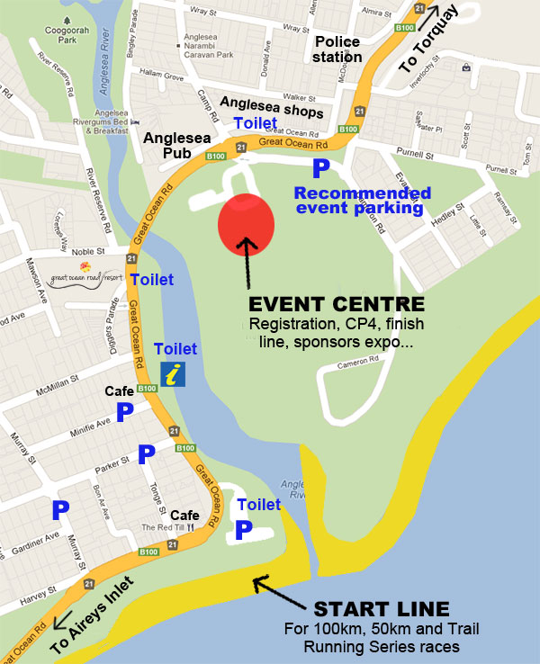
Where: Anglesea Green, the same location as the Event Expo
What: Leg end, team change point and Race Kitchen
Expected time of first runner: 9:05am
Cut off (all runners must depart by): 2:15pm
Are there toilets here?: Yes
Driving directions: On the Great Ocean Road in Anglesea, adjacent to the Bowls Club (same location as Finish Line/Event Centre)
Parking: There is a car park beside the parkland
General notes:
- Competitors come running along the beach (from the left – east) and then come in through the river mouth and into the CP. They grab a drink / food and then keep going along the footpath beside the river
- There will be a coffee cart and food vans here, or there are additional cafés across the road in the town centre
- Support crews and team mates can take hydration and/or nutrition to this point and can provide assistance to your competitors within the confines of the fenced off checkpoint area
- All runners departing this CP who will be on the course after sunset (6:19pm) must carry a white light.

CP5 – 68km/100km or 19km/50km Distillery Creek Picnic Ground
Where: Distillery Creek Picnic Ground
What: Intermediary race kitchen, not a team change over point
Expected time of first runner(100km): 10:30am
Expected time of last runner(100km): 6:30pm
Cut off: n/a
Are there toilets here?: Yes
Driving directions: From Anglesea, drive out of town in the Great Ocean Road towards Aireys Inlet and Lorne. Drive past the ’top shops’ in Aireys Inlet and down the hill then turn right onto Bambra Road. Follow this 2.4km along the valley and then turn left onto Bambra Rd and 400m later turn left into the picnic area and CP.
Parking: There is a small car park at the picnic area otherwise park in the picnic areas on the right hand side of Bambra Rd.
General notes:
- Competitors come running along a great section of single track, grab a drink and some food and keep going
- All runners departing this CP who will be on the course after sunset (6:19pm) must carry a white light.
CP6 – 75km/100km or 26km/50km at Moggs Creek

Where: Moggs Creek Picnic Ground, Boyd Ave, Moggs Creek
What: Leg end, team change point and Race Kitchen
Expected time of first runner(100km): 11:00am
Cut off (all runners must depart by): 7:45pm
Are there toilets here?: Yes
Access limitation: We ask that only one car per runner visits this CP due to limited parking.
Driving directions: From Anglesea, drive out of town on the Great Ocean Road towards Aireys Inlet and Lorne. Keep going through Aireys Inlet and continue 2.5km past the bridge over the Inlet and then turn right onto Old Coach Rd. Turn almost immediately left and follow Old Neuk Rd through the bushland houses and then turn left at the T intersection 600m later, signposted Moggs Creek Picnic Area.
Parking: Access to this CP is limited to one car per runner. The car must have the designated support crew sticker on the windscreen.
There is parking available along Boyd Ave. Please park sensibly so you do not block access in or out for others.
General notes:
- Competitors come running along a nice single track into the CP, interchange / grab some food / clothes and keep going. There will be a terrific atmosphere here as many teams will come through after dark and be very happy and relieved that leg 3 is over. This is a nice picnic area and will have a camp fire or two going
- There will be a coffee cart at the CP from approximately 10:30am – 5:00pm
- All runners departing this CP who will be on the course after sunset (6:19pm) must carry a white light.
CP7 – 84km/100km or 35km/50km Aireys Inlet Skate Park
Where: Aireys Inlet Skate park, opposite the ‘bottom shops’ in Aireys Inlet
What: Intermediary race kitchen, not a team change over point
Expected time of first runner(100km): 11:30am
Cut off (all runners must depart by): 9:15pm
Are there toilets here?: Yes
Driving directions: From Anglesea, drive out of town on the Great Ocean Road towards Aireys Inlet and Lorne. Drive past the ’top shops’ in Aireys Inlet and down the hill. The CP is on the left hand side opposite the shops. If coming from CP6 then drive back out to the Great Ocean Road and turn left, cross back over the inlet bridge and the CP is on the right opposite the shops.
Parking: There is a small car park beside the skate park with additional space further along Inlet Cres and in front of the ‘bottom shops’.
General notes:
- Competitors come running along the gravel foot path from the direction of the bridge, go through the CP and then keep going up to the lighthouse on the winding single track. It is well worth going for a walk up to the lighthouse yourselves. It is a nice spot and offers another terrific view
- All runners departing this CP who will be on the course after sunset (6:19pm) must carry a white light.
Race Finish – 100km Anglesea Green
Where: Anglesea Green. This is the same location as the Event Expo.
What: Race finish line
Expected time of first runner(100km): 12:15pm team and 1:40pm individual
Cut Off – You must arrive at the finish line by 12:30am
Are there toilets here?: Yes
General notes:
- This is the elusive finish line and the site of great accomplishments and satisfaction when runners cross the line
- Runners come along the beach and in through the river mouth and over the finish line
Additional locations
There are numerous additional locations that spectators can see runners outside of these listed CPs. Remember that you cannot provide outside assistance but you can provide plenty of words of support at other locations like:
- 100km: Bells Beach, 15km point and 27km point (they come past here twice)
- 100km: Jan Juc beach and car park, 19km and 22km points (they come past here twice)
- Recommended coffee / ice-cream / chocolate stop! The Great Ocean Road Chocolaterie is located right beside the race course on the Great Ocean Road and makes for a perfect mid morning coffee stop on your way between Anglesea and Torquay (while your runners are on leg 1 and 2). Stop in for some food, drinks, chocolate or other supplies anytime between 9am and 5pm.
- 100km: Coogoorah Park in Anglesea, 51km point
- 100km: The end of Harvey Street on Mt Ingoldsby in Anglesea, 54km/5km point
- 100km: Crossing Distillery Creek Rd behind Aireys Inlet, 60km/11km point
- 100km: Moggs Creek foot bridge, 80km point
- 100km: Aireys Inlet lighthouse and along the cliff top walk, 87km point
- 100km: Urqharts Bluff Beach car park, 94km point.

Celebration Sunday
We’ll be once again providing emphasis on celebrating your accomplishments the day after the race. Based out of the magnificent Anglesea Surf Life Saving Club (SLSC) and on Main Beach, you’re welcome to grab a coffee + muffin / egg and bacon roll / snack… from the cafe then enjoy the magnificent views from the deck whilst catching up with friends and fellow runners to share your ‘war-stories’ from the race. Full activities include:
- Food, coffee from the Main Beach café – from 9:00am in the SLSC
- Group recovery swim / wade – meet at 9:00am on Main Beach
- Yoga on the grass – meet at 9:00am, 30min session on the Main Beach (BYO own towel / mat or use the sand)
- Athlete recovery station – 9:00am – 10:00am in the SLSC
- 2.5km Meli kids run – 9:00am at the SLSC
- ‘The Boat Ramp Battle‘ spectacle event – at 9:45am at the SLSC
- Race presentations to conclude the event – at 10:00am in the SLSC