50KM Course Map & Description

The 50km course route is the second half of the 100km course (Leg 3 & 4) – as per 2023 and earlier.

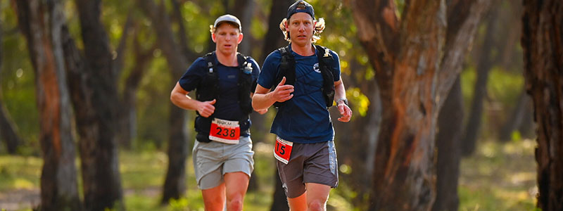
The 50km Surf Coast Century is a journey that leads competitors through an incredibly diverse range of landscapes that will keep you captivated (and smiling) from start to finish … it really is the ‘feel good ultra’!

From towering sea cliffs to renowned Aireys Inlet lighth, remote wilderness, endless single track, come big hills and almost everything in between as part of this incredible race. The 50km course provides a journey where no two footsteps are the same…

The 50km course is split into 2 different legs; the end of each leg being a ‘check point’ where runners can receive support from support crews and and prepare for the next leg. Each leg is quite different from the other, with its own range of landscapes and terrain. There is also an intermediate checkpoint approx halfway along each leg.

50KM COURSE SUMMARY

  1. Cliff Bar Leg 3 – Currawong Falls. 0km – 27km
  2. Fenix Headlamps Leg 4 – Lookouts and Lighthouses. 27km – 50km

The 50km course attracts 2 UTMB and 2 ITRA points for a solo runner. Details here >>.

50km COURSE MAP

DETAILED COURSE DESCRIPTION

CLIF Bar Leg 1 : 0km – 27km

Distance: 27km Elevation gain / loss: 715m / 690m
Leg 3 (only) GPX file: CLICK HERE
Terrain style: A mixture of 2WD, 4WD and single tracks through more remote sections of the coastal bushland (with extensive wildflowers all around). This is the hilliest leg of the race and the crux of the course.
Leg start point: CP4 at Anglesea Lions Park, Great Ocean Road
Leg finish point: CP6 at Moggs Creek Picnic Ground, Boyd Ave, Moggs Creek

The 50km race starts on the golden sands at Anglese Main Beach and then heads inland, crossing the Great Ocean Road and along Bingley Pde for 500m and then turns left across a couple of foot bridges through Coogoorah Park and then along the single track and then a gravel 2WD road uphill. This is the one of first big climbs of the course as you tackle a lung busting climb up ‘Heartbreak Hill’ to the top of Mt. Ingoldsby at the 5km point. 

Turn right at the top and continue along ‘Gilbert Street’, a red clay 4WD track that provides seemingly endless views inland across the Anglesea Heath to the north. Descend down the clay 4WD track (very slippery if wet) to Hutt Gully and then tackle the next decent climb of the day out the other side for another rather epic hill. 

Conquer the hill and you veer right onto ‘Teds Ridge’ track at the 9/10km point where you will start to notice the profusion of wild flowers out in spring blossom all around you. The track descends to cross Distillery Creek Road after which runners turn onto what is arguably the best trail running loop in the Otways – a flowing single track that climbs gradually up the valley past Currawong Falls to a trig point on the ridge at the 18km point on Love’s Track and then descends down into Ironbark Gorge on the other side. Finish the single track and cross the dirt Bambra Road and you arrive at CP5 at the 21km point at the Distillery Creek Picnic Ground and the ‘intermediary race kitchen’ for some nourishment. Note, this is NOT a designated change over point for teams.

Continuing through the picnic area on single track and then turn left on the 2WD dirt road for 2km and then cross the Painkalac Reservoir wall after which the course turns skyward for the final ascent of the leg as you wind your way up a dirt 4WD track to cross Gentle Annie Rd at the 26km mark and then enjoy a long descent down a similar 4WD track to the end of Leg 3 at CP6 at Moggs Creek Picnic Ground, and full ‘Race Kitchen’ as a very welcome landmark.

The Leg 3 is undoubtedly the toughest leg of the course but includes some very scenic trail running through some simply beautiful sections of bush. The coast will seem miles away as you head inland but with the wildflowers in full bloom it should make for some lovely running.

Fenix Headlamps Leg 3 : 27km – 50km

Distance: 23.5km Elevation gain / loss: 490m / 515m
Leg 4 (only) GPX file: CLICK HERE
Terrain style: Another mixture of 2WD, 4WD tracks and single track that returns you to the beach for a stint along the sand to the finish. This has a hilly start but a flat finish.
Leg start point: CP6 at Moggs Creek Picnic Groud
Leg finish point: The finish line at Anglesea Green, Great Ocean Road

After leaving the comforts of CP6 at Moggs Creek runners will follow yet more single track through tall timber forest to emerge at the best look out on the coast (in the Event Manager’s opinion anyway) on Ocean Views Ridge above Moggs Creek at the 30km point. This spectacular lookout sees you about 100m above the water with panoramic views to Lorne in the south west and the Aireys Inlet Lighthouse and beyond to the north east. This lookout is also a turning point of the course for it is here that you will (finally) turn towards Anglesea and start heading for the finish.

Run down the single track descending from the lookout and along Robyn Rd in the Moggs Creek village to cross the quaint footbridge over Moggs Creek at the 81km mark and then turn left then immediately right onto the wide, dirt Old Coach Road which is followed for 1.5km until you turn right to climb up a sandy double track onto another ridgeline offering extensive views. Follow the undulating 4WD track as it passes some large water tanks and then descends down a steep sealed driveway and then down to the double track beside the Painkalac Creek at Fairhaven. Turn right and follow the creek 500m towards the coast until the Great Ocean Road bridge where all runners once again go under the bridge and then curve up and around to the right to the footpath beside the road and across the bridge towards the Aireys Inlet township (this bridge is significantly higher than the bridge at Anglesea and will be far easier to go under!). Follow the gravel footpath – The Surf Coast Walking Track – for 400m beside the Great Ocean Road and you arrive at CP7 and the ‘intermediary race kitchen’ at the Aireys Inlet Skate Park and the 36km point.

Keep following the gravel footpath out of CP7 and it soon winds up hill to the majestic Aireys Inlet Lighthouse – which for many solo runners passing this location at night will be a cool experience. After the lighthouse, runners follow the short sealed road and then the gravel single track along the cliff tops on what is one of the most beautiful sections of the Surf Coast Walk as this 2.7km section winds its way above secluded beaches and rocky pinnacles providing extensive views out to sea and beyond. Descend the stairs in the track at the 90km point down to Sunnymeade Beach and continue along the beach for just 150m and then turn left to climb up a set of stairs and follow the trail as it winds through the bushland, eventually descending with some stairs to the car park at Urqharts Beach.

Cross through the car park and then turn left to run along Urquhart Beach for the next 3.4km to the outskirts of Anglesea. Due to the spread of runners across this section, some runners will encounter this beach at high tide (which will have soft sand and be challenging) and some at low tide (which will have hard sand and be easy). Either way, all runners must remain on the beach until you get to the first set of large timber stairs and the course signage indicating where you must leave the beach. Go up the stairs and continue along Melba Parade and then rejoin the gravel Surf Coast Walk at Point Roadknight as it climbs up to a lookout and then descends to the Anglesea Surf Life Saving Club. Descend the roadway onto Anglesea Main Beach and then curve left up the river mouth and ACROSS THE FINISH LINE!!! in the parkland adjacent to the river.

Congratulations, you have just completed the Surf Coast Century 50km course and stepped into history as a finisher of this incredible race!

COURSE MARKING

The course will be fully marked so you can see where to go – BUT that trail running events are quite different to road running events and you need to actively look for markers and remain aware of where you are. If you have your head up and are looking where you are going, the course will be easy to follow and will be marked with:

  • red and/or orange arrows (pegged into the ground and fixed to trees or bushes)
  • fluoro pink coloured plastic surveyor’s tape (tied to trees or bushes)
  • ‘wrong way’ is indicated by red and white barrier tape across a track / road at ground level. Do not cross red and white tape

COURSE CHANGES

Please note that Rapid Ascent reserves the right to change or alter the course from the description above (due to fire, rain, private landowners or other reasons) and that any changes will be clearly communicated to runners through any of the following means:

  • SMS sent to competitors phone before the race
  • during registration on Friday evening and notices posted on the race notice board
  • at the competitor briefing on Friday night
  • when runners are assembled at the start line or
  • when competitors pass a checkpoint

Please see the Emergency Plans and Procedures section for more emergency plan information.

INTERNATIONAL RECOGNITION

UTMB Qualifying Races & ITRA Points

The 50km and 100km Surf Coast Century individual races are registered with the UTMB as an official qualifying race for the World Series. For further information on UTMB Click Here.

ITRA Points

50km and 100km Surf Coast Century individual races are registered with the ITRA. For more information on ITRA Click Here

  • 50km solo = 2 points
  • 100km solo = 4 points