CHEER AND SUPPORT YOUR RUNNERS
SPECTATORS AND SUPPORT CREWS ARE MOST WELCOME TO JOIN THE ACTIVITY AND ENTHUSIASM OF THE SURF COAST CENTURY, AND THE FOLLOWING INFORMATION IS PROVIDED SO YOU KNOW HOW, WHEN AND WHERE YOU CAN GET INVOLVED.
The course for the 50km Surf Coast Century is very accessible for supporters and spectators – in fact the travelling entourage of supporters going around the course creates a huge atmosphere that is fantastic on the day.
You can easily to see the competitors as they run and you’ll visit some very scenic sections of the Surf Coast along the way.

50km Designated support areas
50km competitors may receive external assistance from support crew and/or team mates at any checkpoint along the course at the following locations:
- CP5 – 21km Distillery Creek Picnic Ground
- CP6 – 27km Moggs Creek Picnic Ground, Moggs Creek
- CP7 – 37km Aireys Inlet Skate Park
Any runners seen to be receiving any external support outside of these checkpoints will be given a 30 minute penalty – this includes collecting water bottles or other hydration or nutrition from spectators as well as items that have been ‘pre-placed’ on the course for collection during the race. This will be strongly enforced. Details on each CP are below.
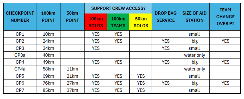
Checkpoint Summary
Checkpoints and recommended viewing spots
Race Start – 0km and 4km at Anglesea Green/ main beach
Where: Anglesea Main Beach.
What: 50km race starts FROM 8:30am
Are there toilets here?: Yes – 100m away
Driving directions: On the Great Ocean Road in Anglesea, beside the river at river mouth
Parking: There is a car park beside the parkland or in side streets next to the Great Ocean Road. We recommend that competitors park their cars in the side streets further away to leave some space free for other visitors and support crews
CP5 – 21km Distillery Creek Picnic Ground
Where: Distillery Creek Picnic Ground
What: Small aid station, not a team change over point
Are there toilets here?: Yes
Parking: The checkpoint is in a small car park on the left of Bambra Rd where there is space for 10 cars. There is additional parking in the picnic areas on the right of Bambra Rd, or park along along the Bambra Road verge. Parking is tight, please ensure 2-way access is maintained.
CP6 – 27km at Moggs Creek
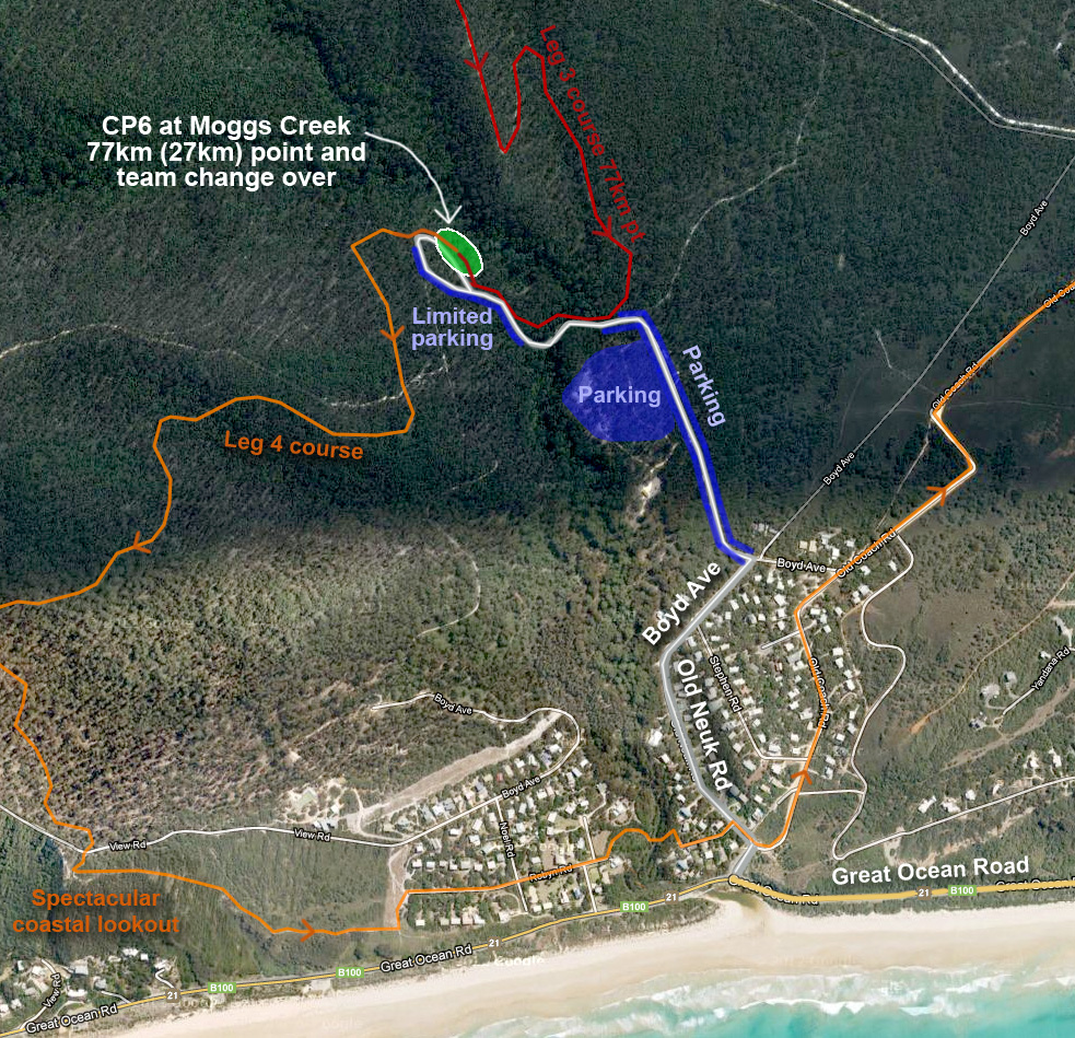
Where: Moggs Creek Picnic Ground, Boyd Ave, Moggs Creek
What: Leg end, team change point and big aid station
Are there toilets here?: Yes
Access limitation: We ask that only one car per runner visits this CP due to limited parking.
Parking: Access to this CP is limited to one car per runner. The checkpoint is at the road end where there is space for approx 20 cars. Otherwise park on the roadside and along Boyd Ave an be willing to walk up to 1km to the CP. This is a busy area, please respect the locals, drive slowly and park sensibly so you do not block access for others
CP7 – 37km Aireys Inlet Skate Park
Where: Aireys Inlet Skate park, opposite the ‘bottom shops’ in Aireys Inlet. (Google maps: (Aireys Inlet Skate Park Public Toilet’)
What: Small aid station, not a team change over point
Are there toilets here?: Yes
Parking: The checkpoint is in the public shelter next to the skate park and public toilet. Park beside the skate park, on Inlet Crescent or in front of the shops on the opposite side of the Great Ocean Road.
Race Finish – 50km Anglesea Green
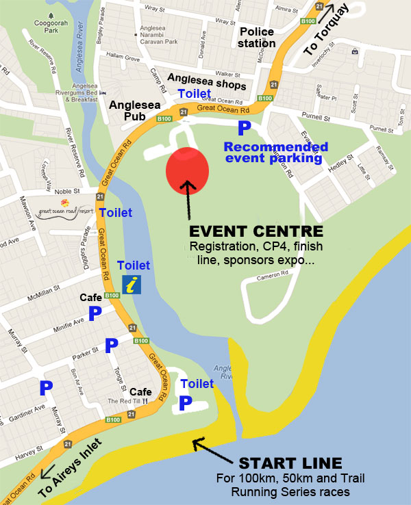
Where: Anglesea Green. This is the same location as the Event Expo.
What: Race finish line
Expected time of first runner(50km): 12:15pm
Are there toilets here?: Yes
General notes:
Runners come along the beach and in through the river mouth and over the finish line
This is the elusive finish line and the site of great accomplishments and satisfaction when runners cross the line
Additional locations
There are numerous additional locations that spectators can see runners outside of these listed CPs. Remember that you cannot provide outside assistance but you can provide plenty of words of support at other locations like:
- Coogoorah Park in Anglesea, 1km point
- The end of Harvey Street on Mt Ingoldsby in Anglesea, 5km
- Crossing Distillery Creek Rd behind Aireys Inlet, 10km
- Moggs Creek foot bridge, 31km point
- Aireys Inlet lighthouse and along the cliff top walk, 37km point
- Urqharts Bluff Beach car park, 44km point.